noaa

added via import

Team Titan - DMSP - S-20

20th flight unit of the DMSP Block 5D series, 6th (last) of the Block 5D-3 series.
Main missions: cloud imagery and MW imaging/temperature/humidity sounding.
Substantial contribution to Space weather.

Project: 
Classification: 
Rating: 
0
No votes yet
Collector Value: 
0
No votes yet

Cospas-Sarsat

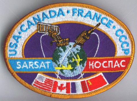
International Cospas-Sarsat Programme is a satellite-based search and rescue (SAR) distress alert detection and information distribution system, established by Canada, France, the United States, and the former Soviet Union in 1979. It is best known as the system that detects and locates emergency beacons activated by aircraft, ships and backcountry hikers in distress. Over the years many countries have joined the project, either as providers of ground segments or as user states. As of 2011, 26 countries (Algeria, Argentina, Australia, Brazil, Chile, People's Republic of China, Greece, India, Indonesia, Italy, Japan, Republic of Korea, New Zealand, Nigeria, Norway, Pakistan, Peru, Saudi Arabia, Singapore, South Africa, Spain, Thailand, Turkey, United Arab Emirates, United Kingdom, Vietnam) and two organizations (Chunghwa Telecom of Chinese Taipei and the Hong Kong Marine Department) are providers of ground segments, while 11 countries are user states (Cyprus, Denmark, Finland, Germany, Madagascar, Netherlands, Poland, Serbia, Sweden, Switzerland, Tunisia).[1] Cospas-Sarsat is based in Montréal, Québec, Canada, and is headed by Steven Lett of the United States.
COSPAS (КОСПАС) is an acronym for the Russian words "Cosmicheskaya Sistema Poiska Avariynyh Sudov" (Космическая Система Поиска Аварийных Судов), which translates to "Space System for the Search of Vessels in Distress". SARSAT is an acronym for Search And Rescue Satellite-Aided Tracking.

Project: 
Classification: 
Rating: 
0
No votes yet
Collector Value: 
0
No votes yet

NOAA I

NOAA-I continues the third-generation operational, polar orbiting, meteorological satellite series operated by the National Environmental Satellite Service (NESS) of the National Oceanic and Atmospheric Administration (NOAA). NOAA-I continues the series of Advanced TIROS-N (ATN) spacecraft begun with the launch of NOAA-8 (NOAA-E) in 1983. NOAA-I will be in an afternoon equator-crossing orbit and is intended to replace the NOAA-11 (NOAA-H) as the prime afternoon spacecraft. The goal of the NOAA/NESS polar orbiting program is to provide output products used in meteorological prediction and warning, oceanographic and hydrologic services, and space environment monitoring. The polar orbiting system complements the NOAA/NESS geostationary meteorological satellite program (GOES). The NOAA-I Advanced TIROS-N spacecraft is based on the Defense Meteorological Satellite Program (DMSP) Block 5D spacecraft and is modified version of the TIROS-N spacecraft (NOAA1-5). 

Project: 
Classification: 
Rating: 
0
No votes yet
Collector Value: 
0
No votes yet

LANDSAT 6

This patch is for LANDSAT 6, the failed launch from VAFB.

Project: 
Classification: 
Rating: 
0
No votes yet
Collector Value: 
0
No votes yet
Subscribe to RSS - noaa